
Owners have offered 165 Broadland sites, 1,971 hectares, for the next Greater Norwich plan. Acle has the most land. Plan comments close at 5pm on 28 September.
Landowners and developers have put forward 165 sites in Broadland for the next Greater Norwich Local Plan. Together they cover just under 1,971 hectares.
That is about a third of the 479 sites received across Greater Norwich. We counted every Broadland entry in the councils’ published call for sites register, parish by parish.
Nothing has been chosen yet. The only consultation open now is on the shape of the plan, not on any site. It closes at 5pm on Monday 28 September.
Where the land is
Acle has more land on offer than any other Broadland parish: six sites and 286 hectares. Acle is about eleven miles east of Norwich. Next comes Honingham, about eight miles west of the city, with five sites and 245 hectares.
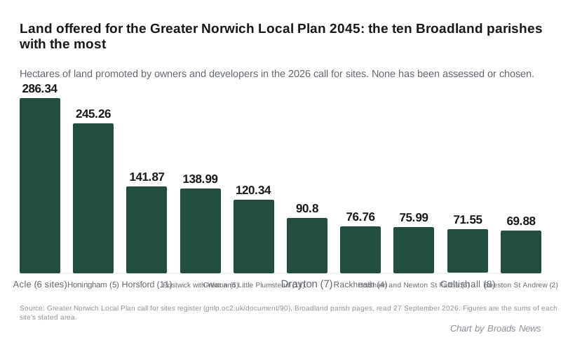
The ten parishes with the most land offered are:
| Parish | Sites | Hectares |
|---|---|---|
| Acle | 6 | 286.34 |
| Honingham | 5 | 245.26 |
| Horsford | 11 | 141.87 |
| Postwick with Witton | 5 | 138.99 |
| Great and Little Plumstead | 11 | 120.34 |
| Drayton | 7 | 90.80 |
| Rackheath | 4 | 76.76 |
| Horsham and Newton St Faiths | 6 | 75.99 |
| Coltishall | 8 | 71.55 |
| Beeston St Andrew | 2 | 69.88 |
Sites were offered in 41 of the district’s parishes. The totals add up each site’s stated area. Two Acle entries share the same address, “land south of South Walsham Road”, so they may overlap.
The twelve biggest proposals
The register puts every site into a size band. Twelve Broadland sites are in the largest, “Strategic 500+ units”. In order of size, they are:
- 212.47 ha, “Honingham Thorpe New Settlement”, for housing, employment and other uses
- 164.89 ha, land south of the A47 at Acle
- 74.86 ha, land off Beighton Road, Acle
- 68.74 ha, land north of the A47 and east of the A1270 at Witton and Postwick
- 66.80 ha, land north of Salhouse Road and east of White House Farm, Sprowston
- 63.65 ha, land to the north of Beeston Park
- 52.43 ha, land east of the Broadland Northway and north of Yarmouth Road, Postwick
- 46.38 ha, land north of the Northway and south of Horsham St Faith
- 34.05 ha, Dairy Farm, north of Plumstead Road at Thorpe End
- 33.28 ha, land south of Spixworth
- 31.83 ha, land at Oaks Farm, bounded by the A1270, south of Thorpe End
- 25.17 ha, land south of South Walsham Road, Acle
Three of the twelve are at Acle. The village already has a housing allocation in the current plan: site B.AC.1, 25.5 hectares and around 340 homes west of the village. One of the new Acle entries is described as land “adjacent southern portion of existing allocation B.AC.1”. Acle’s own rewritten neighbourhood plan is heading for a village referendum.
Below the twelve are:
- 69 sites in the “Major 50-499 units” band
- 68 sites in the “Medium 10-49 units” band
- 16 sites offered for employment or other uses, with no housing
137 of the 165 sites are greenfield. Only 28 are brownfield.
What the register is not
The councils are clear about this. Their introduction says the sites “are presented for information only at this stage and no assessment has been made of their suitability”. It adds: “The promotion of a site at this stage does not mean that it will be allocated in the new Local Plan.”
The scoping document says the same thing about the current consultation. “No proposed site allocations are included in this consultation,” it says, and no comments on sites are being sought (GNLP 2045 scoping consultation, section 5).
Every site will be assessed against a county-wide method. The councils may also reopen the call for sites, or approach owners of land that was not submitted, if there are not enough suitable sites.
Why the numbers are going up
The current Greater Norwich Local Plan was only adopted in March 2024. The councils say a new one is needed because the government’s formula for housing need has changed.
The scoping document sets out the sums (GNLP 2045 scoping consultation, introduction):
- local housing need is now 2,590 homes a year across Greater Norwich
- the adopted plan was built on about 1,920 a year, so need has risen by 34%
- the plan must find sites for around 20,000 more homes between 2026 and 2045 (growth strategy section)
Greater Norwich also falls short on its land supply. It had a 4.85-year housing land supply in April 2025, against the five years required (housing section).
The councils say that shortfall means the “tilted balance” applies to housing applications. Under it, the council must show that a scheme’s harms are “sufficiently serious to outweigh the benefits” before it can refuse. Between 2018 and 2025, 32% of the 14,508 homes built in Greater Norwich were on sites the plan had not allocated.
“New settlements” are one of six possible growth options the document lists. The others include building on brownfield land, urban extensions and growth in villages.
What is open, and until when
The scoping consultation closes at 5pm on Monday 28 September 2026. It asks about the plan’s vision and objectives, its evidence, a growth strategy and how people want to be consulted later. You can answer as many or as few questions as you like.
- Online: on the councils’ consultation portal, which needs an account
- By email: GNLP@norfolk.gov.uk
- By post: The Greater Norwich Local Plan 2045 Team (Floor 5), County Hall, Martineau Lane, Norwich, NR1 2DH
- Help: the plan team on 01603 306603
South Norfolk and Broadland’s launch notice says the consultation is “primarily intended for stakeholders”. It adds that comments “from anyone with an interest in the GNLP area are welcome”.
The dates after this
The councils’ published timetable gives these dates:
| Stage | Date |
|---|---|
| Scoping consultation closes | 28 September 2026 |
| Gateway 1 self-assessment | 30 October 2026 |
| Consultation on plan content and site assessments | 8 June to 20 July 2027 |
| Consultation on the proposed plan | 3 April to 29 May 2028 |
| Submitted for examination | 19 October 2028 |
| Adoption | 30 April 2029 |
The June 2027 consultation is when the councils say they will publish their assessment of each site. It will say whether each one should be allocated. The document calls it “the main chance to have your say on the plan, including its suggested site allocations”.
What it means for you
- A site in the register is an offer, not a plan. Most of the 165 will not be allocated.
- Look up your parish. The register is sorted by district and parish. Each entry gives the address, the area, the proposed use and whether it is greenfield.
- You cannot object to a site yet. That chance comes in June and July 2027. Put it in the diary.
- Tomorrow’s deadline is for the bigger questions. If you have views on where growth should go in general, on new settlements, or on roads, schools and water, this is the stage to say so.
- Applications on other land will keep coming. While the land supply is short, sites that are not allocated can still win permission. Live cases are on our Broadland planning news page.
Sources
- Greater Norwich Local Plan call for sites register, Broadland district and all 41 Broadland parish pages, read 27 September 2026. Site counts, areas, size bands and greenfield or brownfield status are our tally of the register.
- GNLP 2045 Regulation 20 scoping consultation, including the introduction (closing time and how to respond), growth strategy, site allocations and housing sections.
- South Norfolk and Broadland: launch of the Greater Norwich Local Plan scoping consultation.
- Greater Norwich local plan timetable, 30 June 2026, published by Norwich City Council.
- GNLP adopted site allocations, key service centres, for Acle site B.AC.1.
Have your say